Showing posts with label shelling. Show all posts

Monday, April 4, 2016

The first Russian crossing-the-border shelling into Ukraine was on or before July 6th 2014

Russia has been massively shelling Ukraine from Russian territory in 2014. This map has recorded about most of them.

Up till now the first crossing-the-border attack was on Zelenopillya on July 11th
The first recorded cross-border attack was from Gukovo on July 16th.

Now a video is discovered that shows there was already a crossing-the-border attack at least as early as July 6th:


At the time of publishing this blog, it has only 31 views. It has the title 'Бомбление Бирюкове' which auto-translates as 'Bomblenie Biryukova' but probably means something like 'bombardment Biryukova'.

Rockets or shells can be heard flying overhead, with the cameraman trying to follow their path, followed by impacts.
Upload date is July 6th.


In the description it even says June 22nd.
Although the video gives too little clues to geolocate it with certainty, it is a typical 'citizens video' on a personal youtube account. And with 31 views it can hardly be a propaganda video. Therefore it seems likely the video was recorded from Biryukova.

When we check the mentioned map near Biryukova, we see that there is only one trajectory going over that village.


Double checking these trajectories, we find this:


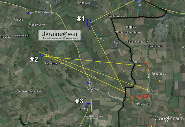
There are three Ukrainian camps in the area. The impacts at these camps have directions indicated by the yellow lines.
#1 was mainly hit by the Gukovo-shellings. #3 was coming from the south. #2 has impacts from three directions, most of those coming from the two southern ones. These two southern ones are close enough to Biryukove to have been filmed as 'flying overhead'.

This video shows that camp #2 was destroyed by July 28th. But since it has impacts from multiple directions it is very well possible that it had been shelled on an earlier date (on or before July 6th) too.

When we trace the yellow lines back to find a firing location, we can see that the most southern one leads to this position:


(At least) Three burn marks from GRAD rocket launches can be seen in two directions.

The other single direction leads to a couple of impacts at camp #1. That is another clue that this shelling had been done independent from the bigger shellings that destroyed the camps. It seems like these might have been some 'probing' attempts, to see what the response would be.

The red lines in the image show tracks that clearly cross the border.

The earliest satellite image (after 2013) dates from 8-8-2014. So this does not help to exactly determine the date of the attack.


Conclusion
The video seems to be very authentic. It makes sense that the Russians would first try out cross-border shelling before massively doing this, in order to see in what way Ukraine would respond. Without a significant answer to this provocation, they moved on and so we got the Zelenopillya-attack a little bit later.
Even though a date of June 22nd seems early, it must be clear that this attack was earlier than the others.

Saturday, July 18, 2015

Donetsk and Avdiivka heavily hit by Russian shelling

Video shows heavy incoming shelling at center of Donetsk:


Another video shows (parts of) the same event:


This is the map of the area with camera positions and approximate impact locations:


Aftermath:


Another aftermath video:


That video shows a piece of a shell being picked up:


That has been identified as a tank shell:
But... be careful. That piece could easily have planted there before it was picked up.

This screenshot can better be used to identify the shelltype:


It seems to be a stabilizing fin stuck into the ground.

This may be something that looks like what we are dealing with here:


Source: wikipedia.

And that happens to be the same kind of shell. So it seems likely that these were HE tank shells.


This video shows shelling in Donetsk continues during the night:


Location is here:


Google maps link.


AVDIIVKA
A residential building in Avdiivka has also been hit:


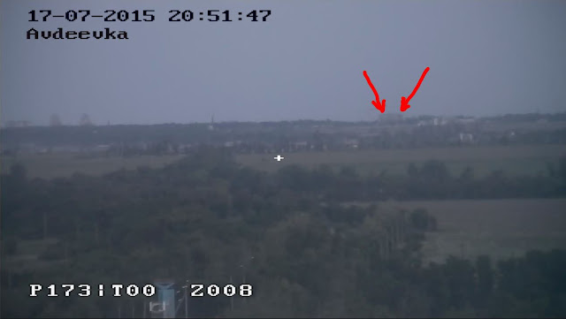
A security camera filmed the incoming shells/explosions:


A screenshot from this video clearly shows where these shells come from:


That's from the South:


That line goes straight to the high apartment buildings near Donetsk Airport that have served as Givi's HQ during the entire battle for Donetsk Airport:


It means they have a good view on thoose buildings in Avdiivka and can see the impacts (or zero them in).
The security camera shows these buildings here:


MORE INFO


CONCLUSION
Russia intensified it's attacks including deliberate targeting of civilian areas (either occupied or not). It is a coordinated attack including Social Media attacks by the St. Petersburg Troll centre.

Of course, as always Russia blames Ukraine. But it may be clear this is Russian instigated shelling.

And we all fear it is the prelude to a new massive summer-offensive.

Sunday, May 3, 2015

Russia shelling Donetsk again and trying to blame Ukraine

The first steps of Russia's new offensive in Ukraine have begun again this weekend. Donetsk residential area has been shelled so they can convince the people there and the public in Russia that Russia's war against Ukraine is justified.

This video shows the aftermath of some of the shelling in Kyiv district:


This map shows most of the impacts shown in the video:


The OSCE look at an impact location that came from the North and COULD have come from Ukrainian side, as well as Russian:


But the other two impacts with the yellows lines indicate the shelling came from North-East direction, which is Russian occupied territory.

Impact 1
There is another video of this impact that is more revealing:


This screenshot will help us to roughly determine the direction of impact:


The rule of thumb here is: direction of impact is perpendicular to the plane through the line on the wall and the impact crater:


(For an extensive explanation and example on this method, see this Volnovakha blog.)

This direction projected on the map looks like this:


The shells came from anywhere in between the direction of the yellow cone.
On a larger scale it looks like this:


Orange line = current frontline according to MilitaryCraps
Read area = 8 km range from which shelling must have come


This screenshot shows that there was an impact tight on the stairs leading to school 58:


This video shows the left (southern) side of the school is still intact:


This streetview from Yandex shows the intact stairs:


It means the whole plateau in front of the door has been blown away by a direct hit.

On the map it can be seen that the direction of impact must have come from the Eastern side, anywhere from almost North to almost South:


On a larger scale it can be seen that this is consistent with the NNe direction of the other impact:


Also it is clear that such an impact never could have come from Western Ukrainian side.


Conclusion
Russia and its propaganda media are playing foul game again. They are deliberately heating up the tension by shelling Donetsk again, like they have done so many times before, and blaming Ukraine for it.

The bad news is that such actions are a prelude to the larger offensives that are coming soon.


Also see: another earlier example of how Russia tries to blame Ukraine for shelling Donetsk.

Here is a Ukrainian language debunking blog about this shelling.

Sunday, February 1, 2015

January 30th shelling in Donetsk likely came from Donbas Cable Factory area

On January 30th Donetsk Kuibyshivs'kyi district got randomly hit by artillery shells. A dozen civilians died. A dozen videos appeared on the incident with gruesome details. Graham Phillips and Patrick Lancaster were quickly at the scene to make their warporn videos. They were also filming a woman crying dramatically without tears and vowing to go to battle to revenge her killed husband:


A CNN reporter was WITH Graham and Patrick and made an item there:

With the help of the community I intensively looked at ALL information that could be found. Here is the result.

These are all the impacts and bodies I have been able to find on the videos:


At least 8 shells, 9 dead people and possibly 2 more or at least wounded.

What's typical, is that one impact at the market near the train station (most Northern one) is TOTALLY out of line with the others. BUT... I do see a pattern:


Since we learned from the mortar attack in Leninsky District that there are some Russian terrorists driving around with a mobile mortar in the back of a truck, I wonder if they might have done something like that here too? Firing from one position (small yellow circle) and firing into different directions, only changing the angle one or two times...


But... only 3 impacts have clearly been filmed. And NONE of the Russian Propaganda channels/videos show impacts. The impact videos available are from civilians. It's even so that the Russian videos DELIBERATELY avoid filming impact craters.
The reason might be obvious: it would mean we can determine the direction and proof that THEY did it. So I am pretty sure all the Russian 'journos' had instructions NOT to film craters and impact sites anymore.

The most clearly recorded crater is this one:


Here is a video of it:


Take note that the OSCE workers are looking at THAT crater! They determined this crater to come from NW. See their report.

This is yandex streetview on that location:


The bus stop (seen in several videos) can be seen in the distance and the approximate position of the crater is indicated.

On Google Maps the situation is like this:


Fortunately we have a rather good photo of the crater and we can use that to determine the direction of impact:


Between the red lines the asphalt is the most damaged. Between red and orange lines less and between orange lines almost zero. A line (yellow) is drawn through the heart of this and it goes approximately from NW to SE.

Here is another one from a video:


Now how does this tell us from which direction it came? You can find a good guide and explanation here.

Basically there are two options:

Up is in case of a mortar. Below is in case of a cannon shell:


So it is a little tricky to definitely decide what it is.

This is an example of such a mortar shell with the tail sticking in the asphalt:


One street away from this location there is another impact:


We can see a big line of holes on the wall at an angle and the impact location is left and just behind the tree.

This composition shows all:

Small red arrows = impacts on the tree
Long red arrow = direction of impact
Red lines = shrapnel pattern

This impact can be determined as from a high angle mortar round coming from NW direction. If so, it is likely that the other one nearby is also from a mortar shell. And thus that one is coming from NW direction (as OSCE said) and not from SE. 

This boy is showing a fragment of a mortar shell:


Contrary to Graham's weeping lady, this boy is genuinely angry (at Poroshenko, because the Russians succeeded in making him believe that the Ukrainian army is shelling his city).
Note that he has blood on his hand.


Third impact - Somova 6
The third impact is at Somova 6. Wikimapia link.


Note that there is a lot of mud on the wall, but hardly any holes from shrapnel. It means the shell did not fly TOWARDS the wall, otherwise it would have been littered with holes. The shell must have flown OVER the building. The shrapnel blasting backwards hit the ground first, blowing up all the mud against the wall.
Some windows are not even broken.
So this looks like a high angle mortar too.

To determine the direction is tricky. But the mud might help a bit:


The centre seems to be more on the right side of the wall.

The blast area could maybe be interpreted like this:


When we take a large margin of error, directions may look like this (coming from anywhere between the red lines):


Putting everything together on the map looks like this:


That big area with complexes MIGHT have been the area where they fired from.

Wikimapia calls this Donbaskabel:


And now THAT's interesting. It is owned by Andrey Kluev, who since March 7th 2014 is wanted for involvement in mass murder and the EU froze his assets [source].

This article and this one show that Donbas Kabel Factory HAS BEEN USED PREVIOUSLY as a firing location!
That makes it VERY LIKELY that it happened again.


This video is not very interesting to watch, but it recorded the sound of the shelling that day. Every now and then a shell hits with quite some time intervals. This excludes a Vaselik mortar, since that rapidly fires 4 rounds.


Conclusion
We know from many instances by now that the Russian mass murderers are deliberately looking to get civilian casualties. We have been able to proof this by determining direction based on impacts. Now they try to hide the craters from being filmed.
But luckily civilians are still filming this. It means it makes it more difficult, but not impossible.

It is very likely that the area of Donbas Cable Factory has been used for this shelling. It is also very likely that this has been done by a mobile mortar on a truck (a fixed mortar would not so easily fire into all directions.)

The distance from the furthest impact area is 10 kms from the frontline. This is out of range for a mortar. It means Russian mass murderers have been firing this from occupied territory.

Now the big question is: what has CNN been doing there with Graham and Patrick?


Many thanks to @xuilolala@_hedder@Gorsefires and @RobPulseNews for all the time they spent sorting all things out.

Tuesday, December 9, 2014

Analysis of shelling at Pervomaisk of Dec 7th

On Dec 7th Pervomaisk has been heavily shelled. Three videos show the destruction.

VIDEO 1 shows the most impacts throughout the city:


Almost all of these impacts can be geolocated.

Video #2 also shows  several impacts, starting with 'the collapsed apartment':


Video #3 is from Dec 8th and shows how people clear the destruction at the 'collapsed apartment' and recover two dead women (which are shown at the end of the video):


All these impacts seem to be from GRAD rockets.

Here is the mapping of almost all shelling of video #1:


More details of the Northern part:


As can be seen two buildings perpendicular to each other are hit on one side. If these impacts are made by the same attack from the same direction (which is likely), then this limits the possible direction quite a lot. 
The yellow lines indicate the limits from what direction the rockets may have come.
It looks like they must have come from the NorthWest - North.

But the 6:02 impact is a special case:


Since it impacted on the ground and the buildings are quite high and it was quite close to the buildings, it could ONLY have gone through the gap between those buildings. Or otherwise it would have hit those buildings. See the long red line in the image above. (Note that there is actually more space than it seems on that image, because the top of the buildings shifted a little bit from their real place, because the satellite took the images at an angle.)
It means this particular one came from almost exact Northern direction.

When we extend that northern line and zoom out, it looks like this:


Orange line = approximate front line according to Russian Propaganda site MilitaryMaps.

It comes from the direction of Zolote.
Could the Russian terrorists have fired these shots?

Yes, easily.
This zoomed in map shows that they can find several concealed positions from where they can fire without too much risk of return fire, because there are a lot of trees around:


The Southern impacts look like this:


Two sides of the same apartment building have been hit. That means it must have come from SW direction, but it can not be narrowed down as much as the Northern ones.

It looks more like this:


Red lines = cone of directions that could possibly hit both sides.

On a larger scale that looks like this:


Distance to the front line is 10 to 16 kms.
Could the Russians have fired these? Easily.

One thing is absolutely clear. This is a different attack. The northern and southern shells come from DIFFERENT sources/directions. They could not have all come from the same direction, because different facing sides of buildings have been hit.

Collapsed apartments
When we look at the impact of the apartments, we see this:

Two sides are damaged:


The whole wall with windows has been blown out:


The debris of the windows lies on the opposite side of the street:


There must have been an explosion INSIDE that blew all this so far away.

On the other side the wall has been completely blown away:


So much that the floor has partly come down and another part risks to fall down as well:


And all the debris seems to lay outwards: 


To be honest... such TOTAL destruction does not seem like the result of a GRAD actually:


Look at all the other impacts in the videos. They are relatively small compared to this.


The only explanation can be that something exploded INSIDE and the air pressure blew out the side and front walls. But could a GRAD rocket do that?
Maybe it was more than one rocket...? Maybe it was a really poor construction anyway...? 

It would be really strange if a GRAD rocket first penetrated the big outer wall and then exploded inside. So maybe a rocket entered through the window and then exploded inside?
If so, it must have been a 'lucky shot' because it also had to enter through the next door, since that one is still standing:


Such things are not impossible though. Shells and rockets land on the weirdest places, just wherever they land.

But we also see this:


There is a pattern of small impacts and holes on the outer wall. THAT indicates something exploded OUTSIDE. But the pattern is quite irregular and strange.

Conclusion: something exploded outside AND something exploded inside...?
It's a mess...
For now let's say that 2 or more GRAD rockets hit this building.

From which direction?
If the outside pattern was created by an exploding GRAD, it must have come perpendicular on the planar that goes through all impact areas. Meaning it must come somewhere from W to SW.
If the other GRAD went through the window and the door it must have come from SW to S.


That means if both GRADs were fired (almost) simultaneously, then they must have come from the SW:


And THAT means they could have been fired by the same launcher as the other southern impacts, with only a minor adjustment for range.

Conclusion
Pervomaisk has been attacked by GRAD rockets from (at least) two different sides. Technically, these COULD have been fired by Ukrainians and they COULD have been fired by Russians.

But it is not likely that Ukrainians did this. It is a random attack on a non-military target with zero military advantage and with a HUGE effect on lost-Western-support and food-for-Kremlin-trolls and you name it.
WHY ON EARTH would they be so stupid to do that?

You can say a lot about Poroshenko, but it is clear that he is NOT a warlord. He is NOT an army general who WANTS to fight. He is NOT a warmonger.
He wants peace. He wants to do business. He orders unilateral cease-fires for crying out loud. When was the last time you heard him say: "Let's just kill all the bastards!"
No, Poroshenko holds peace-talks in Minsk. He does not want to fight. He does not want to randomly kill civilians.

Yet, on the other hand, there are MANY examples of Russians killing innocents (or their own), not caring about them etcetera, deliberately shelling civilian areas, you name it.

So based on directions, we can not conclude who did it. But based on history and track record, it must be clear: the Russians are messing with civilian lives again and they manage to make a good show of it...!

If anybody wants to proof that Ukraine is doing such ridiculous things, you will have to come with SOLID UNDENIABLE proof. Or else just be silent... :D.


UPDATE
A video with English subtitles has been released which is quite revealing:


Do you appreciate this and other articles? Do you think it is important that this information is published?
I'm not working for a newspaper or magazine. If you sponsor me, you help me to keep this blog up and running.
See the Paypal Donate-button in the top right side of this blog or subscribe in the About-me-section.