Monday, October 20, 2014

Proof that Ukraine destroyed the BUKs that were at risk to be captured.

A photo of the disabled BUK parked at A-1428 has been found:


High res version.

Publish date is August 8th, consistent with the dates of the satellite images:

As can be seen, it is at the 7th concrete slab:


Just as on the satellite image:


It is clear that the BUK has been disabled.

So this is the definite and ultimate proof that Ukraine was right when they said they disabled the BUKs that were at risk to be captured.


Conclusion: the (Russian proxy) 'separatists' NEVER captured any Ukrainian (functional or repairable) BUK.


This article is a following up of this one: Google Earth shows Russia used photos from 2010 to prove its proxies captured a BUK.

Also see: President of German Intelligence and media are (AGAIN) making false statements.

President of German Intelligence and media are (AGAIN) making false statements

Bild reports about Schindler, the president of the Bundesnachrichtendienst (Intelligence Service) that the rebels shot down MH17 with a BUK stolen from Ukraine.
As I pointed out in this blog Russia used photos from 2010 to backup their claim that they captured Ukrainian BUKs, they were reported to be captured from the wrong base and the base that did contain the disabled BUKs was never really in control of the Russians proxies.

This casts a lot of doubt on what sources Schindler is using!!
What evidence does he have?
Or let's be VERY specific: what was the hull number of the BUK that had been captured and used to shoot down MH17?
I state here that he can not provide this... or when he does it will turn out to be wrong information.


Earlier (in May!) the German tabloid Bild/Spiegel also reported about 400 American Blackwater mercenaries fighting in Ukraine! The Dutch newspaper De Telegraaf took over that item and also reported about it, refusing to correct it after being shown that this was incorrect.
De Telegraaf said this information came from the German intelligence service.
See this blog.

We all now by now this American mercenaries-story is a joke. It was a Russian pushed propaganda lie that Western Media took over.


Now TWO blatant forms of misinformation has been coming from the German BND: the 'American mercenaries'-story and now this 'captured-BUK' story.

The question is: Is Schindler being paid by the Russians to spread their Propaganda lies into the world? That would be really bad...
Or is he just parroting rumors already available in the public domain? That would be really bad too for the president of an Intelligence Service...


MAJOR UPDATE 20-10-2014
Spiegel/Bild/Schindler are backtracking on their story. Read our discussion on Twitter...

I picked up this message:
Wait, wait, wait.
So this captured BUK story was leaked somehow and the BND does not have any evidence at all!!! Excuse me??

There seemed to have been a broadcast on Deutschlandfunk (radio in Germany) about 'recurring leaks' with a certain Schuster. @ArtWendeley was listening to this and reported about it.


So what we have is this: PKGr is an 8 member organisation that is supposed to control the German Secret Service work.
One of their members incorrectly 'leaked' to Spiegel that Schindler had said that "the separatist had captured a Ukrainian BUK".
And then Bild quotes Spiegel.

Within an 8 member team Schuster MUST know who this person is, but of course he does not want to say this publicly.
Nevertheless: Schindler "had suggested" and then the leak made "we have proof" of this.

So either the whole bunch is backing up for each other, or they have indeed one single mole in their midst...


Wikipedia about Schindler.
Wikipedia about Schuster.


Also see: Google Earth shows Russia used photos from 2010 to prove its proxies captured a BUK
Also see: Proof that Ukraine destroyed the BUKs that were (at risk to be) captured.

Google Earth shows Russia used photos from 2010 to prove its proxies captured a BUK

On June 29th the Russian proxies called 'separatist' by the media reported to have captured one or more BUKs from the Ukrainian army.

They were captured from Military unit A-1402 which was home to the 156th Air Defense Regiment.
See Wikimapia link. It is very close to Donetsk Airport.

Here is a message talking about it:

PHOTO #1


@Black_Bomb is an extreme Russian Twitter Propagandist spreading false messages continuously.

Common practice in the past Ukrainian-Russian war was/is that when Russia wanted to bring in new equipment never been used before by its local proxies, they first would publish some messages that it was captured. A couple of days later they would secretly bring in the hardware and then refer to the false messages to be able to call it 'captured'.

This had happened with the first three T64 tanks that had been brought in too. See this blog.

So, when on June 29th this message appeared it only meant one thing: they were to bring one in from Russia...

When this message came Ukraine reported that they had disabled some old equipment. See the official Ukrainian announcement on June 30th. They say they relocated the good stuff and left behind the old an unusable vehicles that had been further damaged by the war. 
The location indeed had been shelled.
So we will have a look at whether these BUKs were indeed disabled.


PHOTO #2
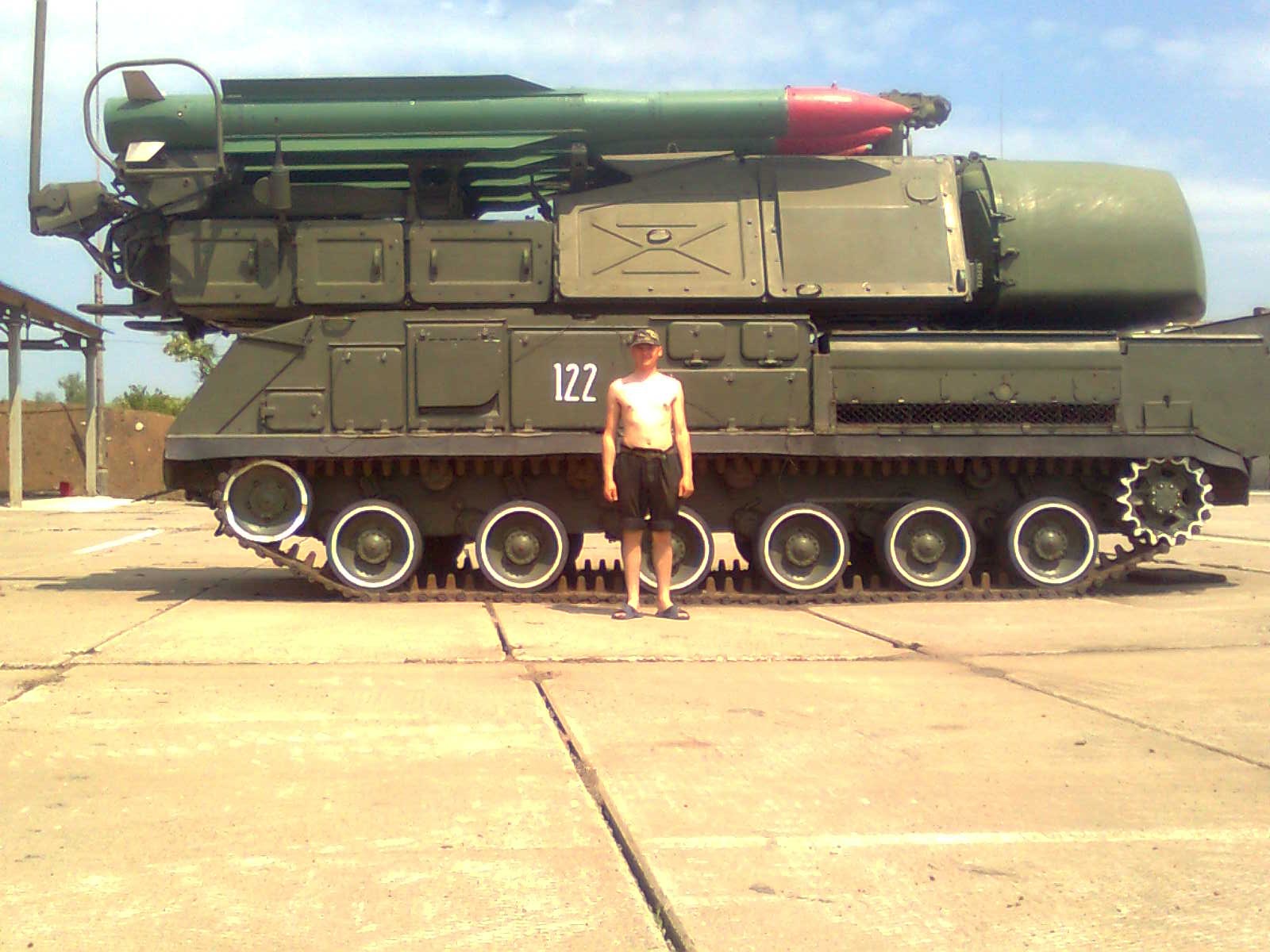
The BUK #122 from photo #1 can also be seen on this photo on VK:


The tree on the background is there. The concrete wall surrounding it is also there. The concrete panels on the ground are the same, including white stripes painted on it. So the photo is made at THE SAME location.
(They do not appear to have been made at the same time though: on the first photo the tree has leaves on the second it doesn't. Yet, the LOCATION is the same.)

NOTE how there are TWO big concrete tiles on the ground between BUK #122 and the sand.

PHOTO #3
The next photo has also been used to proof that BUKs were captured (on this page for instance):


(High res version of this image)

The same two BUKs (113 loader-launch; 122 launch-radar) can be seen on the same pavement in the same position (113 a bit more forward then 122), Now they have a blue storage building behind them, so we can easily geolocate it.

That building can be found here:


Google maps link.

It is military unit 1428 (and not 1402) north of Donetsk Airport. Wikimapia link.

As can be seen on this map, they are 4 kms apart from each other:


When we zoom in we can see this:


There is a BUK there!!! With the same two tiles between it and the sand (meaning it had been driven from it's SAME spot out of the storage building as in the earlier photos):


The launcher-part is at an 45 degrees angle of the vehicle and (of course) there are no missiles on it anymore.

When we go through all the different dates available in Google Earth, we see this:


On April 7th it is not there.
On May 28th it appeared. It has the launcher-part perpendicular to it's body.
On June 19th it has its launcher at 45 degrees to it's body.
Since that date up to Sept 3rd it does not change anymore.

The presumed day of capture was June 29th. But on that day the BUK on the satellite images had its launcher already at 45 degrees! And on photo #3 it is zero degrees!

Something is wrong...

Let's see if the positions of the BUKs match.

There are white paintings on the concrete slabs. This satellite images shows them best:


Photo #3 has some distinct white stripes in front of the BUK. They can be matched with the satellite image like this:


It means BUK #113 in photo #3 is on EXACTLY the same spot as in photo #2 (which dates from October 2010!!)

When we look at the position of photo #1, we can see it is on the 5th slab from the top:


This is ANOTHER position than in photo #2, which is #7 from the top.


Photo #4
Another photo used to claim the 'captured' story:


(High res version)
This is another photo of #113 on the same spot as #2 and #3.


Conclusion 1
We must conclude that photos #1 and #2 where NOT taken at the same time, because the position was different. And photos #2 and #3 WHERE taken at the same time! Together with photo #4.
That means that photo #3 and #4 were 'old photos' used by the Russians as propaganda. They must have been shot during a visit in 2010 when the relations with Ukraine were still good.
But when this is true, it also casts doubt on the date of photo #1. Chances are this is just as good an 'old' photo from the Russian archives, but from another event!

UPDATE: @tyuebatasho points to a VK-page where photos #1 can be found dating January 2011!!!


VK-page: https://vk.com/album-22680516_124376447
Direct link to photo: https://pp.vk.me/c819/u31106954/124376447/w_56252ac7.jpg

Also photos #3 and #4 can be found here dating January 2011. But as argued above, they must have been made in October 2010 already. Even if they are from 2011, they are old and not from June 29th 2014.

Conclusion 2
What can be seen from the high res photos is that these BUKs were indeed already rusty in 2010... confirming the claim from Ukraine that these were old machines.

Conclusion 3
The fact that in May 2014 a BUK was parked outside (possibly #113) and since mid June had not been touched anymore, not even after the Russian proxies supposedly captured the base, shows this BUK was indeed disabled and useless.
This confirms the claim made by Ukraine.

Conclusion 4
But even more: military unit 1428, where the BUKs are located had never really been in Russian control! The ONLY messages about it that I could find on Twitter are that it's radar was destroyed:

This is from Russian media by the way and note how they lie and contradict each other. One says 'militia' destroyed it and the other says 'Ukrainian army' shelled it. More proof that they (always) blame Ukraine for the destruction they themselves cause. It's their habit...


End conclusion
The Russians used photos from their 2010 ARCHIVES to build their claim that BUKs were captured.
They reported the WRONG base these were captured from.
The base where the BUKS WERE located was never really in Russian control.
So they were just lying about this whole story!
It looks like they never captured ANY Ukrainian BUKs AT ALL!


By the way... the next satellite images DO show army base A-1402. As can be seen there are a lot of useless vehicles too. Some changes can be seen throughout the months (indicated with the red boxes). But NO BUKs are there. Even on the last (Sept 3rd) image there are still a lot of vehicles. This again confirms the Ukrainian claim that these are useless. The vehicles that disappeared might have been used by the Russians for spare parts.


Zoomed in on the most detailed satellite image:


Basically all the vehicles here seem to be trucks of some sort and BTRs. Maybe there might even be some GRADs, but it is hard to be conclusive on that.

This is a photo from december 2011 from INSIDE the base:
The water tower can be seen at the left on the satellite images. No BUK here either... 

Thanks to @ain92ru @5urpher and @Saito_section for the help.

Saturday, October 18, 2014

Donetsk hit by Tochka-U?

Two videos showing some extremely large explosion what looks like it could be a Tochka-U rocket:


A third video from Donetsk also shows two smoke plumes:


This one is easy to geolocate:


Google maps link.

On a larger scale:


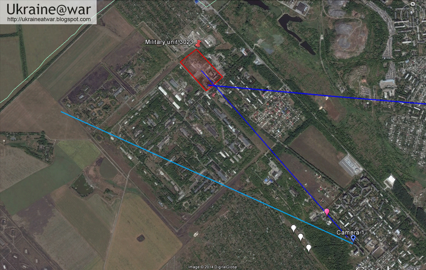
The two blue lines indicate the direction of the smoke plumes. One is comeing from the area where military unit 3023 is located and where earlier end of July a Tochka-U landed.
The other smoke plume is coming from the direction of the airport.

Knowing these two plume locations might help geolocate the other videos (if these are the same plumes of course)

@5urpher was able to find the location of the first video:
This Panoramio photo has almost the same view, but a slightly different position:


It means the map looks like this:


Again with the two blue lines indication the direction of the plumes.

Now the second video can be matched too. This is the location:


All three camera positions together look like this:


When we have a good look at the third video again, we can see that the smoke from the West is actually the from TWO smoke plumes that seem to melt together from that distance:


Who has been hit?
This definitely looks like a serious attack from the Ukrainian army on Russian positions. All these three areas are under Russian control.
What the big explosion was, remains unclear. It is not in the known munition depot nearby. Satelitte images show that between July 30th and September 3rd one of the storages in the munition depot had been blown up, damaging several next to it:


UPDATE:

UPDATE II
Graham Phillips gives us a Damage Report:


This panorama made from the video shows that the explosion happened EXACTLY on the railway leading to the bunker:


Note that left and right on the railway there are still destroyed wagons.

It therefore looks like atrain transport (with explosives, ammunition) had been blown up. Either this was a well performed Ukrainian (sabotage) operation, or something went wrong and the Russians did something really stupid... :P.


If you have any information on what exactly exploded like this, let me know...

Also see: military Unit 3023 hit by Tochka-U end of July

Thursday, October 16, 2014

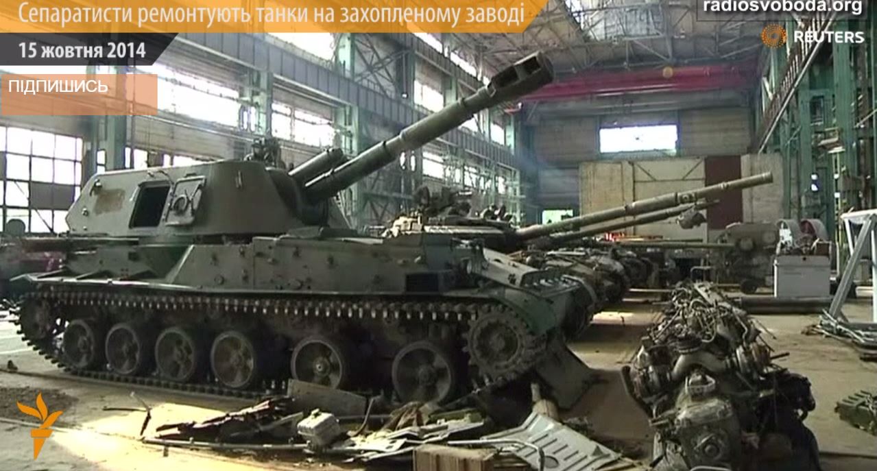
Ahmetovs factory used as repair workshop for TerroRussian tanks

In this video a factory in Donetsk can be seen that is used by the proRussian terroristic separatistic Novorossiya Barbarians Demolotion Republic (sorry, I am confused about the right terminology, so I just use them all) as a repair workshop for damaged or captured tanks:


Here is another video of the same building:


It is a four window high building:


There are only so much factories in Donetsk and there are not many 4 story buildings that could be this.
Actually there is only one:


This satellite image shows the windows perfectly fit with the screenshot: at the top smaller and larger on the bottom.

This other satellite image shows the side also fits with the screenshot:


The red arrows show the window in the side in the screenshot.
The yellow arrow shows the entrance.
The green arrows show the upper roof construction that also fits with the screenshot.

Since there is no other building in Donetsk that fits with these features, this must be the one.

Google maps link.


Ahmetovs factory is use to repair tanks and armor for the Russians...


This video shows another facility with a lot of Russian tanks (only the destroyed one could be Ukrainian):


Not geolocated yet. If anybody has any suggestions... let me know.

Ukrainian company driving from Artemivsk to Saur Mogila

A (long) video from early August came to my attention of a 10+ vehicle Ukrainian company driving from Artemivsk to (almost) Saur Mogila.
This is amazing because we never knew the Ukrainian army had been able to cross the Snizhne-Donetsk line. Also the video shows how the life/work of soldiers on duty look like.

The best quality footage can be found here:


The earliest footage is from August 4th: https://www.youtube.com/watch?v=yEw90V7mQzg
But as I will show later, it must have been from July 31st or earlier.

Helicopter flight (00:00 - 00:14)
This screenshot at 00:02:


resembles this Google Earth position:


Google maps link. It is North of Artemivsk.

At the basecamp (00:14 - 4:58)

00:57


Classic :D (at 00:28):


This screenshot at 01:49


resembles this Panoramio photo:


indicating the location is here (NW of Artemivsk):


Google maps link.

The heavy stuff is here:


Driving and talking 4:58-10:48
Long part talking to the driver on the road from Artemivsk to Debaltseve:


Convoy to Debaltseve 10:48-


Somewhere they take a little detour on a secondary road (11:24)


This probably is because they cannot use the bridge at Luhans'ke.

At 11:49 they drive through a village, which most likely would be Myronivskyi, because that would be the shortest detour:


And indeed there is a Panoramio photo that resembles this place:


So the detour was like this:


To Debaltseve 11:53- 
Then they are on the main road to Debaltseve again (12:02):


Where some other units have taken positions to defend the road/route (12:28):


This position is even visible on Google maps!!!!


Even the white bus can be seen as well as other vehicles and tracks.

At 12:50 it can be seen that the convoy at the back consists of at least 7 vehicles:


with at least 3 driving in front of him that makes 10+ vehicles.

They make another stop at the side of the road (12:53):


where some defenses seem to have been set up.

Debaltseve (13:39-)
Then they enter Debaltseve, where at the first crossroad they pass a roadblock (13:57):


Making geolocation a lot easier at 14:18 :D, just before the main crossroad:


The main crossroad at 14:28:


well guarded (14:33):


Passing the first exit after the city (14:53):


and the main exit to bypass Debaltseve to Lugansk (15:02), making geolocating easy again:


This is how they were driving:


Driving through the countryside (15:16-15:52) 
At 15:16 they drive through some fields:


At 15:40 a road sign can be seen:


This Panoramio photo shows it too:


It means they must have been driving something like this:


Driving through the village Stizhkivske and beyond (15:52-17:21)
At 16:05 a village can be seen:


They go left and at the next crossing they meet some press (16:17):


They continue their drive through the countryside.

16:52:


16:54:


At 16:59 they enter a village again:


On one house it says the streetname:


That street can be found in the outskirts of Shakhtarsk:


It means they are here:


On a larger scale these last spots look like this on the map:


Driving through a mine (17:21-17:51)


This last screenshot can be reconstructed like this:


looking backwards 17:47:


The total route along the mine would then be like this:


Crossing the Donetsk supply line through Hirne (17:52-21:36)
At 17:52 they enter an urban area again, starting with at the right hand a ruin:


 at the 1st crossroad (18:16):


2nd crossroad (18:25)


18:38 taking the corner:


18:50 checking for activity:


19:08 slowly advancing:


19:46 last turn before the railway crossing:


19:54 railway crossing in sight:


Looking backwards:


This is how they went through the village:


At 20:34 they approach the railway crossing:


The busstop on the road from Snizhne to Donetsk:


Roadblock


It looks damaged and abandoned:


It is hard to imagine that this roadblock had vanished without any form of resistance. Either this had been done earlier already, or the camera was off when it happened.
Whatever it was, the weird thing is they had just been able to cross this road. We always thought this was like an impenetrable wall. But the video shows: they did it...


Last stop before Saur Mogila (21:36
The next shot at 21:36 is quite some drive away:


21:48:


22:13:


On the map:


Saur Mogul in sight (22:15-)
Now they enter a hot zone and have to take cover, shots are fired :


Somewhere out there is some trouble, 22:47:


Note the electricity pole just next to the flag.
The position is like this:


Purple line is electricity cables. Three poles have been drawn. The second pole is the first one visible in the shot.

The satellite image is from August 1st. Note that at the right side of the BTR the field is indeed burned too, but at the left side it is NOT! This means the footage is shot BEFORE the first of August.


You can see two bullets hit the ground in front of them (23:29):


His teammate fires some shots 23:37:


A sniper checks if he can find something (23:59):


Something is burning now, or it may be the smoke from the exhaust?


It is behind the third pole and the bushes.

When we zoom in on the map, we see this:


The red arrows show vehicles. The right arrow is exactly in the line of view from the position of the BTR behind the third pole and the bushes.
So it looks like a vehicle got seriously hit and damaged and on the Aug 1st satellite image it was still there. Or it had taken position there and was still there on Aug 1st.
At the left arrow there is another vehicle that either may have been disabled or is positioned there.

When we look at the surroundings something astonishing becomes clear:


There is a third vehicle/wreck a little north of them (red arrow). But right behind them are two MAJOR artillery positions!


Three vehicles are visible in the upper area and 4 in the lower:


And there is even more in the neighborhood:


More vehicles and even another artillery position with 5 vehicles and one command vehicle. That area is also heavily shelled with mortars.

At 24:21 some vehicles are returning, the battle seems to be over:


At 25:41 they start parking their cars for their night camp:


It is located here:


From there they have a nice view on Saur Mogila:


This is the entire route the company took:


Conclusion
Unless the cameraman did not turn on his camera during real battles, it looks like not much fighting had been going on. Only in the end there was a real skirmish, but it didn't last very long.

They had been driving from Debaltseve to (almost) Saur Mogila basically uncontested. Even the so heavily defended and never been captured supply line from Snizhne to Donetsk could be crossed easily. The checkpoint there did not look like a heavy fortress.

Yet we do know there had been some serious and deadly encounters on July 31st in Shakhtarsk.

The impression I get is that the countryside is largely no-mans-land. The Russian (mercenary) forces hide in the cities and pick their battles carefully. 
Only when the hidden invasion by special and regular Russian forces happened they were able to deal with the Ukrainian army.


This video also shows that two weeks after the downing of MH17, the Ukrainian army drove around the crash site without any serious threats. 
There can be no other explanation than that Ukraine wanted to secure the site for free international access.


As we all know Russia and its proxy fighters in Ukraine have obstructed free access to the site.
Do you appreciate this and other articles? Do you think it is important that this information is published?
I'm not working for a newspaper or magazine. If you sponsor me, you help me to keep this blog up and running.
See the Paypal Donate-button in the top right side of this blog or subscribe in the About-me-section.