This photo has been circulating the web, claiming to be the trail of the missile that shot down MH17 and reported to be taken in Torez.

Unfortunately it's all we have. No other photos or videos have turned up from the launch. Nevertheless, this one is good enough, as you will see.
When you right click on it and do an Google Image Search you can see where this image appears on the net. It can be seen that this was on July 17th.
When it first appeared, I assessed this image to be authentic and used it, because:
- it fitted with all the other data
- it appeared very quickly after the event
- Google did not give any results, indicating it was indeed new
Up till today the photo still holds up. Nobody has been able to proof it was false.
UPDATE:
Of course now that I have published this blog, the paid Russian Propaganda Trolls try to discredit this photo. They argue that the sky has clouds in the crash-videos and this one has not. But this does not proof it's a fake photo of course. The launch-site and the crash-site are 20 kms apart. Photographing in a different direction may give a different sky and/or different clouds.
Here is a quick pick from a sky with very different areas of clouds. Depending where you are and in what direction you look, you will get a very different sky:

Ok, back to the launch photo.
An exact geolocation that fitted all the details has not been made, altough other attempts indicated they were in the right area.
UPDATE:
Of course now that I have published this blog, the paid Russian Propaganda Trolls try to discredit this photo. They argue that the sky has clouds in the crash-videos and this one has not. But this does not proof it's a fake photo of course. The launch-site and the crash-site are 20 kms apart. Photographing in a different direction may give a different sky and/or different clouds.
Here is a quick pick from a sky with very different areas of clouds. Depending where you are and in what direction you look, you will get a very different sky:
Ok, back to the launch photo.
An exact geolocation that fitted all the details has not been made, altough other attempts indicated they were in the right area.
Important details are the three poles on the horizon and the single trees in front of them:

These can be found here:

But the pattern does not seem to match. Where are the yellow poles. And there is a BIG mine at that location, so why don't we see any of it in the photo.
I tried to determine the best spot for the cameraman and asked somebody local to try to reproduce the photo, as well as taking photos near the area of the mine.
This photo is made on top of that hill near the mine:

It clearly is the same and the right landscape.
A detail from this photo:
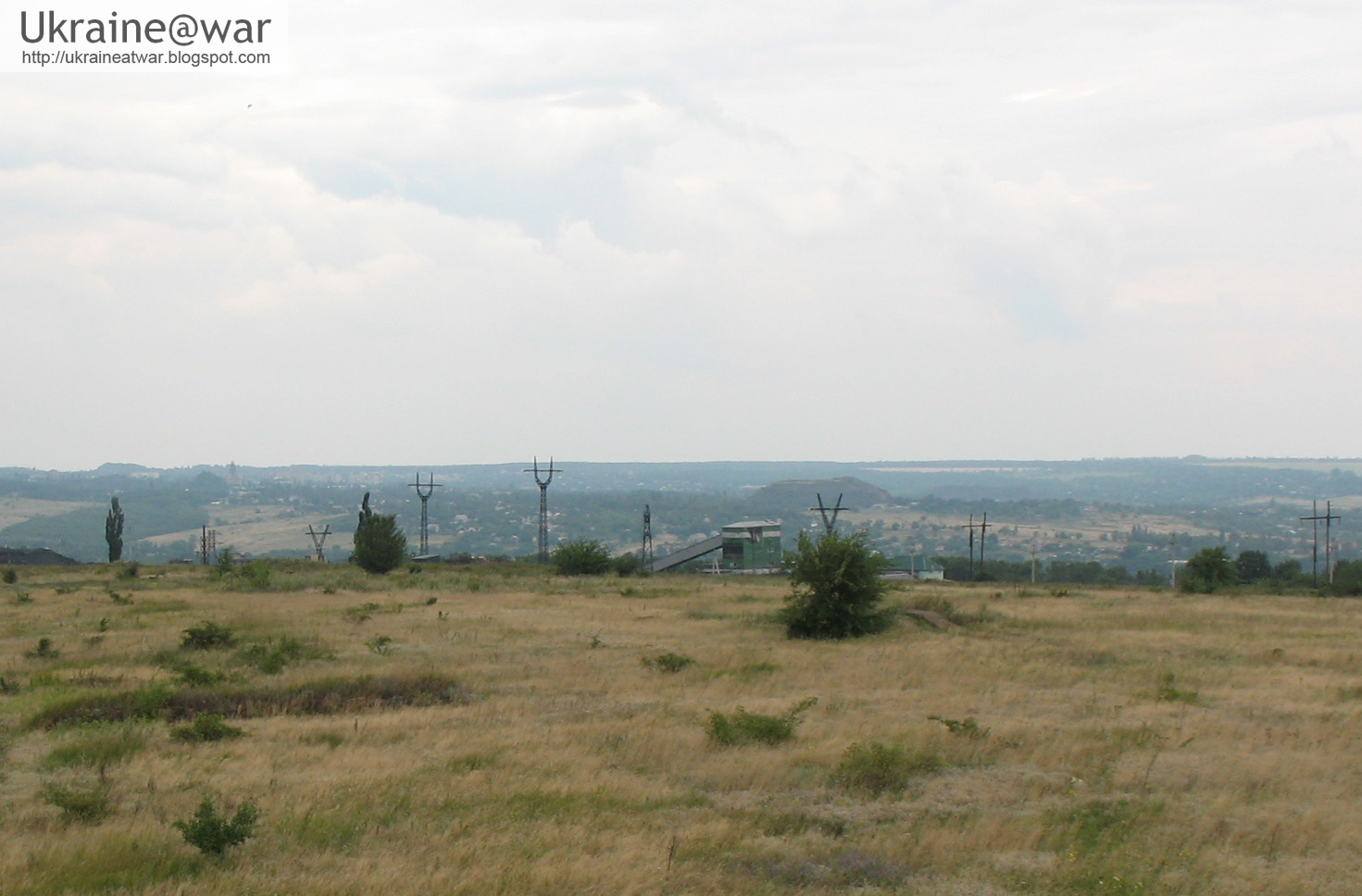
The pole exactly fits with the ones in the photo and the mine clearly is behind the hill, that's why it does not appear on the photo. And the yellow poles of the cable cars are gone. We are definitely in the right direction.
This the photo he made trying to reproduce the original:

As you can see, it doesn't look like it AT ALL. But it IS the right area/village. On the original photo there is a distinguished pole in the village:

This CAN be seen in the photo:

But on the horizon there are trees and no poles can be seen. It means the camera position is way too low. The cameraman was at a much higher level.
On the map it turns out that further back along the lines of sight there are high apartment buildings. When I try to calculate the position along these lines of sight through obvious landscape elements, I get this:
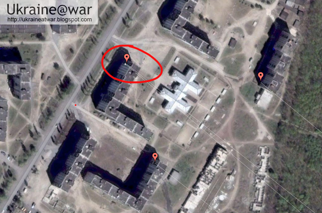
Not all lines EXACTLY fit. But this my be due to the fact that this is really a long distance shot and on such scale the satellite images might get biassed a little bit.
So for further calculations I'll take the average middle one (red circle).
This is as accurately as possible the field of view of the photo:

Now we will draw a line from the camera position right through the middle of the smoke trail. That means a little bit on the right side of the long white pole. We draw that line all the way up to the area where we know that the BUK was:

When we project the tracks of the BUK that we discovered from the satellite images on this map and zoom in on that area, we get this:

As you can see it goes RIGHT THROUGH the tracks!!!
I would say there are two possible launch locations based on this information:

Either in the open in the middle of the field (large yellow circle), because a lot of tracks and turns had been seen there, or in between the cover of the little houses with the trees around it (small yellow circle).
This is the satellite image of the house:

Google maps of the house:
Satellite image of the field:

Conclusion
It is impossible to fake a photo that matches so perfectly with all the other data available. The simple fact that the direction in which we see the smoke trail matches exactly with the tracks we see in the field, means only one thing: the BUK that we have seen driving up there has fired the missile that brought down MH17.
We have been able to narrow down the launch site to one particular field or the houses next to it. Only when the site could be inspected it might be possible to learn more.
Also see: transport of the BUK into Ukraine.
Also see: how the Russians took down MH17Also see: EXIF data of missile launch photo confirmed
Also see: transport of the BUK out of Ukraine
BREAKING UPDATE
#BreakingNews FINALLY the #US publishes satellite intel of how #MH17 was shot down by the Russians pic.twitter.com/B9nyhFWq6z (link->source)
— ConflictReporter (@MiddleEast_BRK) July 22, 2014
Link to CNN reporting about this.
Hi. I'm a reader of your blog and I find you entries very enlightening. Just what I needed at the moment as I couldn't trust the resources gained by the media.
ReplyDeleteAnyhow, just to clarify a thing with you.
Does the Ukrainian army own a BUK-1?
Is it true that the SU25 was flying behind MH17 before the commerficial flight crashed, as what Russia's Defence Ministry stated in the press?
Will be glad to get your feedback.
Ukrainians own BUKs. But the Russian terrorists don't have airplanes or helicopters, so they are not deployed in offensive positions. The Russians though are CONTINEOUSLY shooting down aircrafts. They shot down 7 before MH17. See here: https://twitter.com/uacrisis/status/491575635866025985/photo/1
DeleteThe SU25 can not fly at the altitude the Boeing 777 was flying.
That US image is pretty close to tour findings. You maybe spot on with this. Great work!
ReplyDelete