That means the BUK that shot down MH17 could have communicated with the ones on Russian soil.
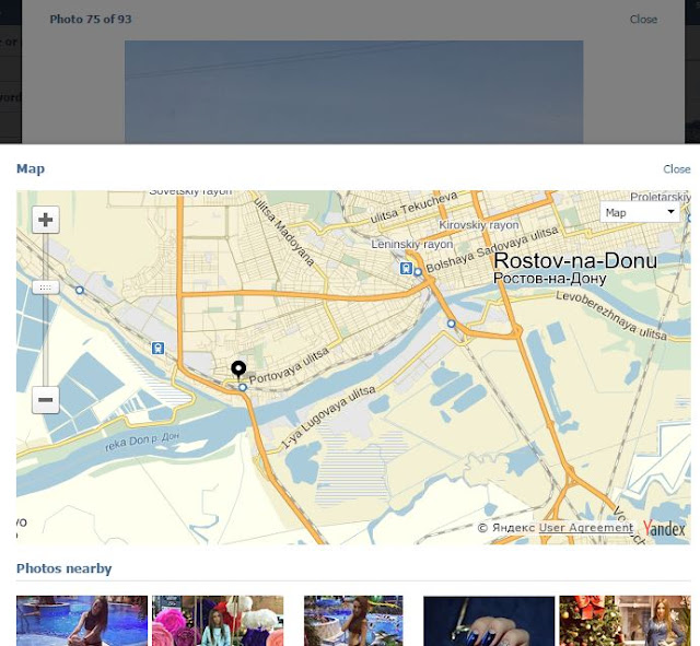
Here is an earlier publication of this BUK-battery, so we can be sure it was there.
Up till now we only had satellite image from 2013 and then September 4th 2014. Now images of 29-6, 2-7, 20-7 and 4-8 have been added.
What has been done to create the images in this blog is to trace every unique track and position on every subsequent satellite image where it FIRST appears. If it's also on the next map, it is further ignored, although it doesn't mean it hasn't been also used on that date. Also commonly used tracks and roads are ignored.
By using this method, we can see unique activity that must have happened before any specific satellite date.
Legend
Red lines = unique tracks
Red areas = areas where vehicles can be seen
Orange areas = areas where multiple tracks can be seen, likely indicating a deployment position
Green areas = tracks into/from treelines indicating (abandoned) campsites.
29-6

Not much can be seen, but there are two noticeable areas. The first is at the known BUK-team position (green area), where they had a kitchen and dug-in trenches.

Electricity poles run from left to right on the image above and there are tracks leading to/from these poles. So it is very well possible that on June 29th a team was already there making preparations, or already positioned and waiting.
The other suspicious area is this one:

Clearly tracks can be seen of a heavy machine manoeuvring in the corn. Because of the corn the tracks are obscured, but they are still so profound that they are still visible.
Farmers don't damage their own corn like that. Military vehicles do.
2-7
On the July 2nd image only a rare new track can be seen in the north:
2-7
On the July 2nd image only a rare new track can be seen in the north:

For the rest there is not happening anything.
20-7
On the July 20th map (2 days after MH17 was shot down), several new tracks can be seen:

There is a big one leading to the trenched position (green). And there are several tracks (red lines) and positions with multiple tracks and turns (orange areas).
On the July 20th map (2 days after MH17 was shot down), several new tracks can be seen:

There is a big one leading to the trenched position (green). And there are several tracks (red lines) and positions with multiple tracks and turns (orange areas).
Note that the July 20th map ends at 1/3 of the bottom. It's only the darker area. The lighter bottom part is from the July 2nd image. That's why the red track leading to/from the trenches can not be traced further down.
The orange area at the right looks like this:

We can clearly see vehicle tracks arriving and leaving the area again, as well as positions where they must have been deployed and operated. It is possible that multiple vehicles where deployed here at the same time, or that one or more visited the same spot again on another day and a little bit further from the previous position.
This is the middle orange area/position:

In the upper side we can see one position similar to the four we saw in the previous area. This is an indication that only one vehicle caused all these different tracks on different days.
This is the left orange area:

Not much can be seen, because it is covered with layers of mist/clouds. Only one small part of a track can be seen, along the red line in the area.
The August 2nd image shows all the tracks:

Because part of the tracks where already visible on the July 20th image, all of them must have been made on the 20th of July.
They just look like tracks, although it can not be 100% excluded that it was a deployment area. Either way it shows their was activity here.
These tracks and positions are a clear indication that the BUK-battery was fully operational before July 20th.
2-8
In the two weeks up to August 2nd some more activity can be seen:

Very close to the upper right area on the July 20th image some more similar activity can be seen:

The upper left positions look like this:

Clear positioning and manoeuvring can be observed, but not necessarily by multiple vehicle on one day.
In the south of the area there has been activity too:

Since the July 20th image did not include this area, it might as well have been from an earlier date then July 20th. It's unclear what exactly happened here.
4-9
Up to September 4th their has been a lot of activity North, in the middle and in the East near the lake:

During August major Russian invasions and offensives took place in Ukraine, so a lot of activity is logical.
The upper red area shows very intensive use (image enhanced):

As well as some objects/vehicles (yellow circles).
In the middle there is a red area that looks like this (enhanced image):

It is also intensively used and for the first time vehicles can be seen (yellow circles). The upper one near the blue vehicle icon seems to show BUK vehicles, but the usual white tips of the missiles can't be seen:

Near the lake in the East several trucks can be seen at a campsite in the trees:

Most likely this is a basecamp for some GRAD launcher company, since North of it several GRAD launch sites with burn marks can be seen as well as a lots of tracks leading up further North:

The American ambassador to Ukraine @GeoffPyatt tweeted about one of these launch sites:
Therefor it seems very unlikely that these tracks North of the road and the lake-camp have anything to do with the BUK battery.Удари реактивних систем залпового вогню на території України (25/26 липня) pic.twitter.com/JewexXUGOz— Geoffrey Pyatt (@GeoffPyatt) July 27, 2014
14-9
The activities in the area can be separated into the northern part and southern part:

Up north it looks like this:

Tents and vehicles can be seen.
A little bit westward some very typical lined up positions can be seen as well as a single truck in the field:

In the South something big is going on:

Up to nine very long trucks can be seen hidden between the trees. In the other red areas, tents and more vehicles can be seen:

6-10-2014
Strangely enough all the activity in the south ceased to exist by October 6th except for some tracks:

In the middle area a lot of white and other small trucks can be seen:

In the upper area the whole battery of BUKs can be seen lined up:

Here the white tips from the missiles CAN be seen.
With this particular line up it seems likely that the strange patterns on the 14-9 image nearby are also from these BUKs parked in the field.
Why they do this..., I have no idea. As if they WANTED satellites to capture them :P.
22-2-15
On the Febr 22th 2015 image a VERY LARGE camp can be seen South:

Just a part of it:

The timing of this camp is during the Debaltseve offensive. That started by the end of January and lasted until February 18th. So it looks like this camp existed to support this offensive.
The green areas show activity, but no vehicles can be seen anymore. These vehicles therefore most likely had been sent to Debaltseve in the previous weeks.
The green areas show activity, but no vehicles can be seen anymore. These vehicles therefore most likely had been sent to Debaltseve in the previous weeks.
The middle area had a significant upgrade (image enhanced):
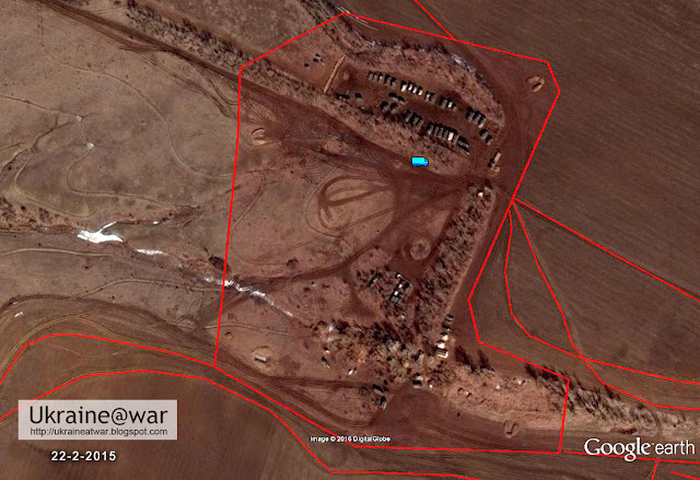
But it is hard to tell if the BUKs are really there. The vehicles in the upper part more resemble MLRS than a BUK:

The northern area seems abandoned.
Conclusions
When we draw all the activity in one map, we see this:

The Area of Operation for the BUK-battalion is within the yellow ellipse with a concentration in the light blue ellipse.
The large blue ellipse is more than once used as a camping ground. It seems by february 2015 to also have included or merged with the smaller blue area. Whether the BUK-battery was still operational by that time is unclear, but there is a good chance it relocated or even stopped.
The July 20th activity TOTALLY falls within the narrower Area of Operation of the BUK battery (light blue ellipse):

Therefore we should conclude that these tracks are also made by the same BUK battery.
Tracks visible on a July 20th satellite image are made PRIOR to that date. They had been made anywhere between June 29th and July 20th.
It is safe to assume that the BUK battery was already there and operational on the fatal July 17th.
That means it was on 25 kms distance of the BUK launch site that brought down MH17. An ideal distance to setup communications with the BUKs on Russian soil.
Most likely this Russian BUK battery communicated with the MH17-BUK and got it's data and final instruction from Russians commanders within Russia territory themselves.
Epilogue
Right from the start after MH17 was taken down, I said there must have been a Russian BUK battery South of Marinovka.
Then I found positions West of Kuybyshevo with radars.
Then images of BUKs East of Kuybyshevo appeared posted on VK.
Then satellite images appeared showing BUKs parked in a row for all to see.
The sceptical, truthers and trolls kept arguing on and on.
Now I have found (with a little help from Google and such) evidence the battery was indeed operational during that fatal day.
The crash of MH17 was not a coincidence...
Then I found positions West of Kuybyshevo with radars.
Then images of BUKs East of Kuybyshevo appeared posted on VK.
Then satellite images appeared showing BUKs parked in a row for all to see.
The sceptical, truthers and trolls kept arguing on and on.
Now I have found (with a little help from Google and such) evidence the battery was indeed operational during that fatal day.
The crash of MH17 was not a coincidence...
UPDATE
Now there are also a 16-7 and 23-7 map of the area in Google Earth.
The 16-7 map confirms what we already thought. That the southern activity was not from after 20-7, but before:

The inset on the bottom right might actually be a BUK (with the white tips of the missiles merged together):

The activity in the northern area can not be observed on the 16-7 map. And thus this activity has been taken place between 16-7 and 20-7: